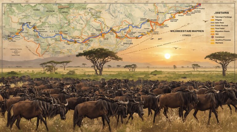
The Great Migration is one of the most powerful wildlife movements on Earth. Every year, over a million wildebeest move across East Africa in search of fresh grass and water.
But the movement is not random. It follows a pattern. That is where a map wildebeest migration guide becomes useful. A good migration map helps you understand where the herds are, and what you can expect to see. You do not need to guess. You can plan with confidence.
In this article, we’ve mentioned the key reasons why migration maps matter and how they help you understand wildebeest routes clearly.
What Is the Wildebeest Migration Route?
Wildebeest move in a circular path between two main areas:
- Serengeti in Tanzania
- Maasai Mara in Kenya
The route changes slightly each year because rainfall controls the movement. When rain falls in one region, grass grows. The herds follow that grass.
Here is the basic annual pattern:
- January to March – Southern Serengeti
- April to May – Central Serengeti
- June to July – Western Corridor
- August to October – Maasai Mara
- November to December – Return to Serengeti
A wildebeest migration map view helps you see this cycle clearly. Without it, the movement can feel confusing.
Why You Should Use a Migration Map
You cannot rely on guesswork. The herds move based on rain and grass. That means timing matters.
Here is why a migration map helps:
1. You See the Big Picture
A map shows the full route. You understand how far the herds travel. You see how rivers, plains, and borders affect movement. This helps you grasp the scale of the migration.
2. You Pick the Right Location
Not every camp sits near the herds all year. If you want river crossings, you need to be near the Mara River. But, if you want calving season, you need southern Serengeti. A map wildebeest migration guide helps you choose the right area.
3. You Avoid Poor Timing
The migration does not stay in one place for long. If you visit the wrong region at the wrong time, you may miss the herds. A map reduces that risk.
4. You Understand Animal Behavior
The herds move for survival. When you look at a migration map, you start to see patterns:
- Grass growth zones
- River crossing points
- Predator hotspots
You learn how nature controls the route.
Key Areas on a Wildebeest Migration Map
Understanding the major regions helps you plan better. A clear map wildebeest migration guide shows these zones in order. Each area plays a role in the annual movement.
Here are the main regions you need to know:
- Southern Serengeti – Calving Season
The herds gather in the southern Serengeti, from January to March. The plains have short grass during this time. That grass attracts large numbers of wildebeest. This is calving season.
Thousands of calves are born within a few weeks and the timing helps protect the young. When many calves are born at once, predators cannot catch them all.
On a map wildebeest migration plan, this region is marked as the starting point of the yearly cycle.
You will see:
- Large open plains
- Huge herd numbers
- Lions, and hyenas nearby
- Newborn calves standing within minutes
This period gives you constant movement. Herds spread across wide, flat ground. Viewing is often clear because there are few trees.
- Western Corridor – River Crossings Begin
Around June and July, the herds move west. They enter the Western Corridor of the Serengeti. This shift happens after the grass dries in the south. Here, they meet the Grumeti River.
Crossings begin in this region. They are not always dramatic. Some are calm. Others are tense. Timing depends on rainfall and river levels.
A map wildebeest migration guide shows how the route curves west before turning north. This bend in the route makes sense when you look at grass patterns and water sources.
In this area, you can expect:
- Long lines of moving herds
- Riverbanks with waiting animals
- Crocodiles in the water
- Thick bush in some sections
The Western Corridor is less crowded than the Mara. It still offers strong wildlife activity.
- Maasai Mara – Famous River Crossings
From August to October, many herds reach the Maasai Mara in Kenya. This is the northern part of the migration route.
The Mara River crossings happen during this phase. A map wildebeest migration route clearly shows the border crossing between Tanzania and Kenya. It also marks key river points where herds gather.
This stage draws the most attention because crossings can be intense. Wildebeest hesitate at steep banks. Then they rush down together.
You can expect:
- Steep riverbanks
- Strong river currents
- Large crocodiles
- Lions waiting nearby
- Dust rising from moving herds
This is the most photographed phase of the migration. The action is fast and unpredictable.
How Rain Shapes the Map
Rain controls everything. Wildebeest follow fresh grass. Fresh grass grows where rain falls.
That means:
- Early rain can shift movement
- Late rain can delay crossings
- Heavy rain can change river levels
A static map shows the usual route. But real-time updates matter too.
When you review a map wildebeest migration plan, always consider current weather.
How a Map Helps You Plan a Safari
You want to see action. You also want comfort and good viewing.
Here is how to use a migration map wisely:
Step 1: Choose the Season
Decide what you want to see.
- Calving season
- River crossings
- Open plain herd movement
Each season happens in a different location.
Step 2: Match Camps to the Map
Look at where camps are located. Compare them with migration zones. You want short travel times. Long drives reduce viewing time.
Step 3: Understand Driving Distances
The Serengeti is large. The Maasai Mara is smaller but still wide. A map wildebeest migration view shows you:
- Park boundaries
- River systems
- Major plains
This helps you avoid underestimating distances.
Common Mistakes Without a Migration Map
Skipping the map leads to confusion. Here are mistakes many people make:
- Booking a northern camp in March
- Expecting river crossings in May
- Thinking the herds stay in one country all year
- Ignoring rainfall shifts
A simple map prevents these errors.
Benefits of Using a Reliable Migration Map Source
Not all maps are equal. Some are too simple. Others are outdated. A good map wildebeest migration guide should:
- Show seasonal movement clearly
- Explain monthly changes
- Mark major rivers
- Separate Serengeti and Maasai Mara zones
- It should also update based on current movement patterns.
When maps are updated regularly, you make smarter decisions.
Why Visual Planning Works Better Than Text Alone
Reading about the migration helps. But seeing the route makes it clear. A map allows you to:
- Connect months with locations
- See direction of travel
- Understand border crossings
- Spot key river points
You process visual information faster. That saves time and prevents confusion.
Quick Summary: What a Migration Map Gives You
Here is what you gain from using a map wildebeest migration guide:
- Clear view of annual movement
- Better safari timing
- Smarter camp selection
- Realistic expectations
- Understanding of animal behavior
- Reduced planning mistakes
- You stay informed. You plan with purpose.
Final Thoughts
The Great Migration is powerful. It covers vast distances. It changes with the rain. Without a map, the movement feels unpredictable. With a map, you see the pattern.
You understand when herds gather in the south. You see why they move west. You know when they reach the Maasai Mara.
A map wildebeest migration guide does not promise exact sightings. It gives you structure and clarity. For accurate route guidance and updated movement insights, refer to Wildebeest Sightings when planning your safari.